
![]()
![]()
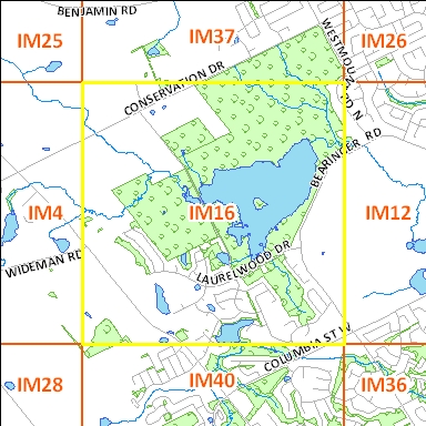
Clicking on an adjacent tile will open corresponding page
| File Name | File Size | File Description |
| 1930_IM16_TIF | 5 M | TIF image format |
| 1 KB | Transformation text file used by GIS software to place the aerial TIF (tfw) photograph in a true map coordinate location. |
|
| 1930_IM16_JPG | 122 KB | JPG image format - converted from TIF image |
| 1.3 M | PDF image format - converted from TIF image | |
| 1930_IM16_KMZ | 1.2 MB | KMZ image format - view in Google Earth - converted from TIF Image
|
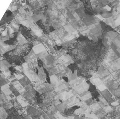
Original images used to create this image tile : 1930 : A2142_51, A2142_52 |
||
| File Name | File Size | File Description |
| 1946_IM16_TIF | 4.3 M | TIF image format |
| 1 KB | Transformation text file used by GIS software to place the aerial TIF (tfw) photograph in a true map coordinate location. |
|
| 1946_IM16_JPG | 127 KB | JPG image format - converted from TIF image |
| 1.5 M | PDF image format - converted from TIF image | |
| 1946_IM16_KMZ | 1.2 MB | KMZ image format - view in Google Earth - converted from TIF Image
|
Original images used to create this image tile : 1946 : A10062_93, 10062_92 |
||
| File Name | File Size | File Description |
| 1955_IM16_TIF | 1.4 M | zipped GeoTIFF image format |
| 1955_IM16_JPG | 209 KB | JPG image format - converted from TIF image |
| 680 KB | PDF image format - converted from TIF image | |
| 1955_IM16_KMZ | 2.3MB | KMZ image format - view in Google Earth - converted from TIF Image
|
Original images used to create this image tile : 4322_33, 4322_34, 4321_25, 4321_26
|
||
| File Name | File Size | File Description |
| 1963_IM16_TIF | 156 KB | zipped GeoTIFF image format |
| 1963_IM16_JPG | 21 KB | JPG image format - converted from TIF image |
| 1963_IMI6_KMZ | 137 KB | KMZ image format - view in Google Earth - converted from TIF Image
|
Original images used to create this image tile :
|
||
Right click file name and 'Save Target As'
| File Name | File Size | File Description |
| 1966_IM16.tif | 706 KB | TIF image format |
| 1 KB | Transformation text file used by GIS software to place the aerial TIF (tfw) photograph in a true map coordinate location. |
|
| 582 KB | PDF image format - converted from TIF image | |
| 1966_IM16.kmz | 201 KB | KMZ image format - view in Google Earth - converted from TIF Image |
Original images used to create this image tile : A19409_98
|
||
The aerial photographs are projected to the UTM coordinate system, zone 17, based on the North American Datum of 1983.
Please email any questions, comments or suggestions to :
Eva Dodsworth, Geospatial Data Services Librarian
University Map Library, 2008